United Kingdom FactbookDraft
November 2026 Edition
United Kingdom Factbook · National chapter / GBR
Geography

ⓘ
2021 Factbook flag mirror; image identity has not been individually audited. Source.
Last updated: November 5, 2026
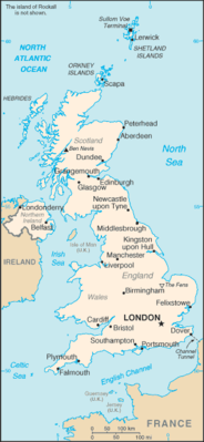
Map image could not be loaded. Open source image.
ⓘ
CIA World Factbook map, February 2021 media edition. Identity reviewed; current boundaries have not been audited. visual contact sheet or original identity check; does not verify current boundaries Boundaries, place names and designations may be dated or disputed; original annotations retained. SHA-256: dd49e6dcf47c72bb0f45e15e5bcf5faa3cc0d971d39b160c4176a6376375e53a. Provenance and inspection record.ⓘ
World Bank directory coordinates; approximate location, not a country center. Coordinate reference date is not supplied by the directory. Natural Earth 1:110m land (2022 source); simplified coastline, no political borders. Map source. Land SVG SHA-256: CF26056A39DC0A5B02F65704E279DFA86E77539A8387D0B2C92F907A67739E5E.Sections in Geography
Geography
Location:2
Western Europe, islands - including the northern one-sixth of the island of Ireland - between the North Atlantic Ocean and the North Sea; northwest of France
Geographic coordinates:3
54 00 N, 2 00 W
Map references:4
Europe
Area:5
Surface area: 243,610 square kilometers (2024)
Area - comparative:7
twice the size of Pennsylvania; slightly smaller than Oregon
Land boundaries:8
Coastline:9
12,429 km
Maritime claims:10
Climate:11
temperate; moderated by prevailing southwest winds over the North Atlantic Current; more than one-half of the days are overcast
Terrain:12
mostly rugged hills and low mountains; level to rolling plains in east and southeast
Elevation:13
Natural resources:14
coal, petroleum, natural gas, iron ore, lead, zinc, gold, tin, limestone, salt, clay, chalk, gypsum, potash, silica sand, slate, arable land
Land use:15
agricultural land:70.3% (2023 est.)
arable land:25% (2023 est.)
permanent crops:0.2% (2023 est.)
permanent pasture:45.2% (2023 est.)
forest:13.4% (2023 est.)
other:14.7% (2023 est.)
Irrigated land:16
Population distribution:17
the core of the population lies in and around London, with significant clusters found in central Britain around Manchester and Liverpool, in the Scottish lowlands between Edinburgh and Glasgow, in southern Wales in and around Cardiff, and in far-eastern Northern Ireland, centered on Belfast
Natural hazards:18
winter windstorms; floods
Geography - note:19
lies near vital North Atlantic sea lanes; only 35 km (22 mi) from France and linked by tunnel under the English Channel (the Channel Tunnel or Chunnel); because of heavily indented coastline, no location is more than 125 km (78 mi) from tidal waters
Notes & sources
- Location. Reference edition; observation: dates as stated in text. Field last updated: not supplied; profile fallback: 2025-12-04 13:07:35 -0500 (not a field revision date); needs review. Reference source. Edition retrieval date: not supplied (retrieval only). ↩
- Geographic coordinates. Reference edition; observation: dates as stated in text. Field last updated: not supplied; profile fallback: 2025-12-04 13:07:35 -0500 (not a field revision date); needs review. Reference source. Edition retrieval date: not supplied (retrieval only). ↩
- Map references. Reference edition; observation: dates as stated in text. Field last updated: not supplied; profile fallback: 2025-12-04 13:07:35 -0500 (not a field revision date); needs review. Reference source. Edition retrieval date: not supplied (retrieval only). ↩
- Area. Reference edition; observation: dates as stated in text. Field last updated: not supplied; profile fallback: 2025-12-04 13:07:35 -0500 (not a field revision date); needs review. Reference source. The archived total area has no reference year and territorial coverage may differ from World Bank surface area. World Bank: 243,610 square kilometers (2024). Reference: 243,610 square kilometers. Edition retrieval date: not supplied (retrieval only). ↩
- Surface area. Surface area: observation 2024; checked 2026-10-29; single source. World Bank World Development Indicators. The archived total area has no reference year and territorial coverage may differ from World Bank surface area. World Bank: 243,610 square kilometers (2024). Reference: 243,610 square kilometers. ↩
- Area - comparative. Reference edition; observation: dates as stated in text. Field last updated: not supplied; profile fallback: 2025-12-04 13:07:35 -0500 (not a field revision date); needs review. Reference source. Edition retrieval date: not supplied (retrieval only). ↩
- Land boundaries. Reference edition; observation: dates as stated in text. Field last updated: not supplied; profile fallback: 2025-12-04 13:07:35 -0500 (not a field revision date); needs review. Reference source. Edition retrieval date: not supplied (retrieval only). ↩
- Coastline. Reference edition; observation: dates as stated in text. Field last updated: not supplied; profile fallback: 2025-12-04 13:07:35 -0500 (not a field revision date); needs review. Reference source. Edition retrieval date: not supplied (retrieval only). ↩
- Maritime claims. Reference edition; observation: dates as stated in text. Field last updated: not supplied; profile fallback: 2025-12-04 13:07:35 -0500 (not a field revision date); needs review. Reference source. Edition retrieval date: not supplied (retrieval only). ↩
- Climate. Reference edition; observation: dates as stated in text. Field last updated: not supplied; profile fallback: 2025-12-04 13:07:35 -0500 (not a field revision date); needs review. Reference source. Edition retrieval date: not supplied (retrieval only). ↩
- Terrain. Reference edition; observation: dates as stated in text. Field last updated: not supplied; profile fallback: 2025-12-04 13:07:35 -0500 (not a field revision date); needs review. Reference source. Edition retrieval date: not supplied (retrieval only). ↩
- Elevation. Reference edition; observation: dates as stated in text. Field last updated: not supplied; profile fallback: 2025-12-04 13:07:35 -0500 (not a field revision date); needs review. Reference source. Edition retrieval date: not supplied (retrieval only). ↩
- Natural resources. Reference edition; observation: dates as stated in text. Field last updated: not supplied; profile fallback: 2025-12-04 13:07:35 -0500 (not a field revision date); needs review. Reference source. Edition retrieval date: not supplied (retrieval only). ↩
- Land use. Reference edition; observation: dates as stated in text. Field last updated: not supplied; profile fallback: 2025-12-04 13:07:35 -0500 (not a field revision date); needs review. Reference source. Edition retrieval date: not supplied (retrieval only). ↩
- Irrigated land. Reference edition; observation: 2018. Field last updated: not supplied; profile fallback: 2025-12-04 13:07:35 -0500 (not a field revision date); needs review. Reference source. Edition retrieval date: not supplied (retrieval only). ↩
- Population distribution. Reference edition; observation: dates as stated in text. Field last updated: not supplied; profile fallback: 2025-12-04 13:07:35 -0500 (not a field revision date); needs review. Reference source. Edition retrieval date: not supplied (retrieval only). ↩
- Natural hazards. Reference edition; observation: dates as stated in text. Field last updated: not supplied; profile fallback: 2025-12-04 13:07:35 -0500 (not a field revision date); needs review. Reference source. Edition retrieval date: not supplied (retrieval only). ↩
- Geography - note. Reference edition; observation: dates as stated in text. Field last updated: not supplied; profile fallback: 2025-12-04 13:07:35 -0500 (not a field revision date); needs review. Reference source. Edition retrieval date: not supplied (retrieval only). ↩